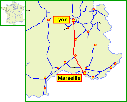
Bestand:Autoroute A7 FR 2.svg

Afmetingen van deze voorvertoning van het type PNG van dit SVG-bestand: 500 × 400 pixels Andere resoluties: 300 × 240 pixels | 600 × 480 pixels | 960 × 768 pixels | 1.280 × 1.024 pixels | 2.560 × 2.048 pixels.
Oorspronkelijk bestand (SVG-bestand, nominaal 500 × 400 pixels, bestandsgrootte: 106 kB)
Bestandsgeschiedenis
Klik op een datum/tijd om het bestand te zien zoals het destijds was.
| Datum/tijd | Miniatuur | Afmetingen | Gebruiker | Opmerking | |
|---|---|---|---|---|---|
| huidige versie | 29 sep 2013 16:58 |  | 500 × 400 (106 kB) | NordNordWest | upd |
| 28 sep 2013 22:21 |  | 500 × 400 (105 kB) | NordNordWest | c | |
| 28 sep 2013 22:19 |  | 500 × 400 (105 kB) | NordNordWest | upd | |
| 5 aug 2006 14:36 |  | 500 × 400 (105 kB) | Mortadelo2005 | Mapa de la Autoroute A7 (Francia). Es una copia del mapa Image:Autoroute A7 FR.svg,del usuario madcap, cambiando los topónimos tradicionales en polaco por topónimos franceses. |
Bestandsgebruik
Dit bestand wordt op de volgende 2 pagina's gebruikt:
Globaal bestandsgebruik
De volgende andere wiki's gebruiken dit bestand:
- Gebruikt op cs.wiki.x.io
- Gebruikt op da.wiki.x.io
- Gebruikt op de.wiki.x.io
- Gebruikt op en.wiki.x.io
- Gebruikt op es.wiki.x.io
- Gebruikt op fr.wiki.x.io
- Gebruikt op it.wiki.x.io
- Gebruikt op ja.wiki.x.io
- Gebruikt op lmo.wiki.x.io
- Gebruikt op oc.wiki.x.io
- Gebruikt op ro.wiki.x.io
- Gebruikt op simple.wiki.x.io
- Gebruikt op sk.wiki.x.io
- Gebruikt op sv.wiki.x.io
- Gebruikt op uk.wiki.x.io
- Gebruikt op www.wikidata.org
- Gebruikt op zh.wiki.x.io