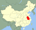
Bestand:China Anhui.svg

Afmetingen van deze voorvertoning van het type PNG van dit SVG-bestand: 705 × 599 pixels Andere resoluties: 282 × 240 pixels | 565 × 480 pixels | 904 × 768 pixels | 1.205 × 1.024 pixels | 2.409 × 2.048 pixels | 1.000 × 850 pixels.
Oorspronkelijk bestand (SVG-bestand, nominaal 1.000 × 850 pixels, bestandsgrootte: 210 kB)
Bestandsgeschiedenis
Klik op een datum/tijd om het bestand te zien zoals het destijds was.
| Datum/tijd | Miniatuur | Afmetingen | Gebruiker | Opmerking | |
|---|---|---|---|---|---|
| huidige versie | 13 aug 2008 17:11 |  | 1.000 × 850 (210 kB) | Joowwww | added missing laos/vietnam border |
| 14 mei 2008 12:06 |  | 1.000 × 850 (208 kB) | Joowwww | {{Information |Description=An SVG map of China with Anhui province highlighted Legend:<br />Image:China map legend.png |Source=self-made; based on CIA public domain maps: *http://www.lib.utexas.edu/maps/middle_east_and_asia/china_admin_91.jpg *http:/ |
Bestandsgebruik
Dit bestand wordt op de volgende pagina gebruikt:
Globaal bestandsgebruik
De volgende andere wiki's gebruiken dit bestand:
- Gebruikt op ace.wiki.x.io
- Gebruikt op bg.wiki.x.io
- Gebruikt op bo.wiki.x.io
- Gebruikt op br.wiki.x.io
- Gebruikt op bs.wiki.x.io
- Gebruikt op ce.wiki.x.io
- Gebruikt op cs.wiki.x.io
- Gebruikt op en.wiki.x.io
- Gebruikt op eo.wiki.x.io
- Gebruikt op es.wiki.x.io
- Gebruikt op eu.wiki.x.io
- Gebruikt op fa.wiki.x.io
- Gebruikt op fi.wiki.x.io
- Gebruikt op fr.wiki.x.io
Globaal gebruik van dit bestand bekijken.

