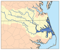
Bestand:Chowanrivermap.png
Chowanrivermap.png (500 × 417 pixels, bestandsgrootte: 156 kB, MIME-type: image/png)
Bestandsgeschiedenis
Klik op een datum/tijd om het bestand te zien zoals het destijds was.
| Datum/tijd | Miniatuur | Afmetingen | Gebruiker | Opmerking | |
|---|---|---|---|---|---|
| huidige versie | 9 feb 2007 19:53 |  | 500 × 417 (156 kB) | Kmusser | This is a map of eastern portion of the Chowan/Roanoke watershed, showing the Chowan, Meherrin, Nottoway and Blackwater rivers as well as Albemarle Sound. For the western portion of the watershed see [[:Image:Ro |
Bestandsgebruik
Dit bestand wordt op de volgende pagina gebruikt:
Globaal bestandsgebruik
De volgende andere wiki's gebruiken dit bestand:
- Gebruikt op arz.wiki.x.io
- Gebruikt op bg.wiki.x.io
- Gebruikt op ceb.wiki.x.io
- Gebruikt op de.wiki.x.io
- Gebruikt op en.wiki.x.io
- Gebruikt op es.wiki.x.io
- Gebruikt op fr.wiki.x.io
- Gebruikt op hu.wiki.x.io
- Gebruikt op ja.wiki.x.io
- Gebruikt op pl.wiki.x.io
- Gebruikt op pt.wiki.x.io
- Gebruikt op ru.wiki.x.io
- Gebruikt op sr.wiki.x.io
- Gebruikt op www.wikidata.org
