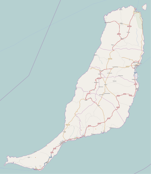
Bestand:Fuerteventura (Canary Islands) - OSM Mapnik.svg

Afmetingen van deze voorvertoning van het type PNG van dit SVG-bestand: 520 × 599 pixels Andere resoluties: 208 × 240 pixels | 416 × 480 pixels | 666 × 768 pixels | 889 × 1.024 pixels | 1.777 × 2.048 pixels | 2.298 × 2.648 pixels.
Oorspronkelijk bestand (SVG-bestand, nominaal 2.298 × 2.648 pixels, bestandsgrootte: 2,01 MB)
Bestandsgeschiedenis
Klik op een datum/tijd om het bestand te zien zoals het destijds was.
| Datum/tijd | Miniatuur | Afmetingen | Gebruiker | Opmerking | |
|---|---|---|---|---|---|
| huidige versie | 25 nov 2010 14:49 |  | 2.298 × 2.648 (2,01 MB) | Muro de Aguas | updating |
| 2 jul 2010 15:25 |  | 2.298 × 2.648 (1,9 MB) | Muro de Aguas | updating | |
| 16 apr 2010 18:10 |  | 2.298 × 2.648 (1,89 MB) | Muro de Aguas | updating | |
| 27 feb 2010 18:18 |  | 2.298 × 2.648 (1,89 MB) | Muro de Aguas | {{OpenStreetMap|name=Fuerteventura|source=http://www.openstreetmap.org/?lat=28.4165&lon=-14.1515&zoom=10&layers=B000FTFTT}} Category:OpenStreetMap maps of the Canary Islands Category:Maps of Fuerteventura Category:Maps of the Canary Islands |
Bestandsgebruik
Dit bestand wordt op de volgende 9 pagina's gebruikt:
Globaal bestandsgebruik
De volgende andere wiki's gebruiken dit bestand:
- Gebruikt op ar.wiki.x.io
- Gebruikt op ast.wiki.x.io
- Gebruikt op en.wiki.x.io
- Puerto del Rosario
- Fuerteventura Airport
- Tostón Lighthouse
- Punta La Entallada Lighthouse
- Morro Jable Lighthouse
- Punta Jandía Lighthouse
- Punta Martiño Lighthouse
- Module:Location map/data/Spain Fuerteventura
- Module:Location map/data/Spain Fuerteventura/doc
- Puerto del Rosario Lighthouse
- Template:Lighthouses of the Canary Islands map
- Gebruikt op es.wiki.x.io
- Playa del Matorral
- Faro de Morro Jable
- Faro de Punta La Entallada
- Hornos de cal de la Guirra
- Montaña de Tindaya
- Ajuy
- Playa de la Goleta (Corralejo)
- Cofete
- Castillo de El Cotillo
- El Cotillo
- Faro del Puerto del Rosario
- Faro de Punta Jandía
- Faro Tostón
- Faro de Punta Martiño
- Castillo de Fuste
- Lajares (La Oliva)
- Plantilla:Mapa de localización de Fuerteventura
- Casillas del Ángel
- Tetir
- El Matorral (Fuerteventura)
- Tarajalejo
- Gebruikt op fr.wiki.x.io
- Tuineje
- Pájara
- La Oliva
- Antigua (Fuerteventura)
- Puerto del Rosario
- Betancuria
- Corralejo
- Caleta de Fuste
- Morro Jable
- Péninsule de Jandía
- Modèle:Géolocalisation/Fuerteventura
- Wikipédia:Atelier graphique/Cartes/Archives/juin 2015
- Wikipédia:Atelier modèle de géolocalisation/Archives/2015
- Parc naturel de Corralejo
Globaal gebruik van dit bestand bekijken.