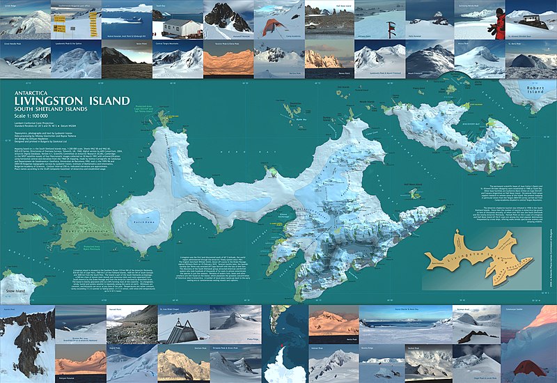
Bestand:Livingston-Greenwich-map.jpg

Grootte van deze voorvertoning: 800 × 550 pixels. Andere resoluties: 320 × 220 pixels | 640 × 440 pixels | 1.024 × 705 pixels | 1.280 × 881 pixels | 2.560 × 1.761 pixels | 7.828 × 5.386 pixels.
Oorspronkelijk bestand (7.828 × 5.386 pixels, bestandsgrootte: 5,07 MB, MIME-type: image/jpeg)
Bestandsgeschiedenis
Klik op een datum/tijd om het bestand te zien zoals het destijds was.
| Datum/tijd | Miniatuur | Afmetingen | Gebruiker | Opmerking | |
|---|---|---|---|---|---|
| huidige versie | 27 mei 2007 17:22 |  | 7.828 × 5.386 (5,07 MB) | Apcbg | Reverted to earlier revision |
| 23 mei 2007 19:38 |  | 7.828 × 5.386 (19,01 MB) | Apcbg | == Summary == L.L. Ivanov et al, Antarctica: Livingston Island, South Shetland Islands (from English Strait to Morton Strait, with illustrations and ice-cover distribution), 1:100000 scale topographic map, Antarctic Place-names Commission of Bulgaria, Sof | |
| 15 jun 2006 12:47 |  | 7.828 × 5.386 (5,07 MB) | Apcbg | L.L. Ivanov et al, Antarctica: Livingston Island, South Shetland Islands (from English Strait to Morton Strait, with illustrations and ice-cover distribution), 1:100000 scale topographic map, Antarctic Place-names Commission of Bulgaria, Sofia, 2005 Rel | |
| 25 mei 2006 07:27 |  | 7.828 × 5.386 (4,79 MB) | Apcbg | L.L. Ivanov et al, Antarctica: Livingston Island, South Shetland Islands (from English Strait to Morton Strait, with illustrations and ice-cover distribution), 1:100000 scale topographic map, Antarctic Place-names Commission of Bulgaria, Sofia, 2005 Rel |
Bestandsgebruik
Dit bestand wordt op de volgende pagina gebruikt:
Globaal bestandsgebruik
De volgende andere wiki's gebruiken dit bestand:
- Gebruikt op af.wiki.x.io
- Gebruikt op ar.wiki.x.io
- Gebruikt op bg.wiki.x.io
- Gebruikt op ca.wiki.x.io
- Gebruikt op cs.wiki.x.io
- Gebruikt op cv.wiki.x.io
- Gebruikt op de.wiki.x.io
- Gebruikt op el.wiki.x.io
- Gebruikt op en.wiki.x.io
- Cartography
- Wikipedia:Picture peer review/Map of Livingston Island and Greenwich Island
- Wikipedia:Featured picture candidates/April-2007
- Wikipedia:Featured picture candidates/Map of Livingston Island and Greenwich Island
- User:Apcbg/Livingston-Greenwich-map
- Barclay Bay
- Portal:Maps
- Map layout
- Cartographic design
- Wikipedia:Wikipedia for Schools/Welcome/Geography
- Portal:Geodesy
- Gebruikt op eo.wiki.x.io
- Gebruikt op es.wiki.x.io
- Gebruikt op fa.wiki.x.io
- Gebruikt op fr.wiki.x.io
- Gebruikt op he.wiki.x.io
- Gebruikt op hr.wiki.x.io
- Gebruikt op hu.wiki.x.io
- Gebruikt op it.wiki.x.io
- Gebruikt op ja.wiki.x.io
- Gebruikt op ka.wiki.x.io
- Gebruikt op kk.wiki.x.io
- Gebruikt op la.wiki.x.io
- Gebruikt op mk.wiki.x.io
- Gebruikt op ms.wiki.x.io
- Gebruikt op my.wiki.x.io
- Gebruikt op nn.wiki.x.io
- Gebruikt op no.wiki.x.io
- Gebruikt op pl.wiki.x.io
Globaal gebruik van dit bestand bekijken.
