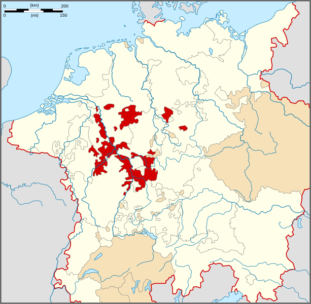
Bestand:Locator Electoral Rhenish Circle.svg

Afmetingen van deze voorvertoning van het type PNG van dit SVG-bestand: 613 × 600 pixels Andere resoluties: 245 × 240 pixels | 491 × 480 pixels | 785 × 768 pixels | 1.046 × 1.024 pixels | 2.093 × 2.048 pixels | 1.165 × 1.140 pixels.
Oorspronkelijk bestand (SVG-bestand, nominaal 1.165 × 1.140 pixels, bestandsgrootte: 193 kB)
Bestandsgeschiedenis
Klik op een datum/tijd om het bestand te zien zoals het destijds was.
| Datum/tijd | Miniatuur | Afmetingen | Gebruiker | Opmerking | |
|---|---|---|---|---|---|
| huidige versie | 28 mrt 2010 17:19 |  | 1.165 × 1.140 (193 kB) | Sir Iain | {{Information |Description=Locator Map of the Electoral Rhenish Circle of Holy Roman Empire. |Source=PERTHES ATLAS Geschichte |Date=28/03/2010 |Author=Sir Iain |Permission=Attribution ShareAlike 3.0 |other_versions= }} {{cc-by-sa-3.0}} [[Category:Reichs |
Bestandsgebruik
Dit bestand wordt op de volgende pagina gebruikt:
Globaal bestandsgebruik
De volgende andere wiki's gebruiken dit bestand:
- Gebruikt op az.wiki.x.io
- Gebruikt op bg.wiki.x.io
- Gebruikt op cs.wiki.x.io
- Gebruikt op el.wiki.x.io
- Gebruikt op en.wiki.x.io
- Electoral Palatinate
- Thurn und Taxis
- Koblenz
- Electorate of Mainz
- Electorate of Cologne
- Gelnhausen
- Arenberg
- Nieder-Isenburg
- Electoral Rhenish Circle
- Electorate of Trier
- Wikipedia:WikiProject Former countries/Holy Roman Empire task force
- Template:Electoral Rhenish Circle
- Category:Electoral Rhenish Circle
- Burgraviate of Rheineck
- Gebruikt op es.wiki.x.io
- Gebruikt op et.wiki.x.io
- Gebruikt op fr.wiki.x.io
- Gebruikt op no.wiki.x.io
- Gebruikt op pt.wiki.x.io
- Gebruikt op ru.wiki.x.io
- Gebruikt op sv.wiki.x.io
- Gebruikt op zh.wiki.x.io