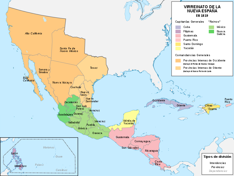
Bestand:Mapa del Virreinato de la Nueva España (1819).svg

Afmetingen van deze voorvertoning van het type PNG van dit SVG-bestand: 799 × 599 pixels Andere resoluties: 320 × 240 pixels | 640 × 480 pixels | 1.024 × 768 pixels | 1.280 × 960 pixels | 2.560 × 1.921 pixels | 885 × 664 pixels.
Oorspronkelijk bestand (SVG-bestand, nominaal 885 × 664 pixels, bestandsgrootte: 1,06 MB)
Bestandsgeschiedenis
Klik op een datum/tijd om het bestand te zien zoals het destijds was.
| Datum/tijd | Miniatuur | Afmetingen | Gebruiker | Opmerking | |
|---|---|---|---|---|---|
| huidige versie | 13 nov 2018 11:58 |  | 885 × 664 (1,06 MB) | Milenioscuro | User created page with UploadWizard |
Bestandsgebruik
Dit bestand wordt op de volgende pagina gebruikt:
Globaal bestandsgebruik
De volgende andere wiki's gebruiken dit bestand:
- Gebruikt op af.wiki.x.io
- Gebruikt op ar.wiki.x.io
- Gebruikt op ast.wiki.x.io
- Gebruikt op azb.wiki.x.io
- Gebruikt op be-tarask.wiki.x.io
- Gebruikt op be.wiki.x.io
- Gebruikt op br.wiki.x.io
- Gebruikt op ca.wiki.x.io
- Gebruikt op cs.wiki.x.io
- Gebruikt op de.wiki.x.io
- Gebruikt op en.wiki.x.io
- Gebruikt op es.wiki.x.io
- Demografía de México
- Suroeste de Estados Unidos
- Reino de Nueva Vizcaya
- Mexicanos
- Comandancia General de las Provincias Internas
- Organización territorial del Virreinato de Nueva España
- Intendencia de Guadalajara
- Portal:Nueva España/La foto del mes
- Historia territorial del Estado de México
- Conflicto entre Guatemala y México de 1842 y 1882
- Virreinato de Nueva España
- Regionalización de la Nueva España y división territorial de México
- Texas (Nueva España)
- Anexo:Gobernantes de las Californias
- Guerras indias de Texas
Globaal gebruik van dit bestand bekijken.

