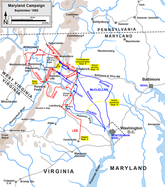
Bestand:Maryland Campaign.png

Grootte van deze voorvertoning: 531 × 600 pixels. Andere resoluties: 212 × 240 pixels | 425 × 480 pixels | 680 × 768 pixels | 906 × 1.024 pixels | 1.601 × 1.809 pixels.
Oorspronkelijk bestand (1.601 × 1.809 pixels, bestandsgrootte: 576 kB, MIME-type: image/png)
Bestandsgeschiedenis
Klik op een datum/tijd om het bestand te zien zoals het destijds was.
| Datum/tijd | Miniatuur | Afmetingen | Gebruiker | Opmerking | |
|---|---|---|---|---|---|
| huidige versie | 29 mrt 2011 23:46 |  | 1.601 × 1.809 (576 kB) | Hlj | Update to graphical format of rivers and roads. |
| 7 mrt 2011 00:07 |  | 1.601 × 1.809 (450 kB) | Innotata | New version from enwiki, uploaded by original uploader. Upload summaries: "Fixed DC boundary. Adobe Illustrator source file at http://www.posix.com/CWmaps/"; "minor graphical changes to conform to style used by most ACW maps; added legend and scale." | |
| 26 apr 2007 03:09 |  | 1.502 × 1.700 (528 kB) | Qbek | {{Information |Description=Map of the en:Maryland Campaign of the en:American Civil War, actions Sept. 3-15. Drawn by Hal Jespersen in Macromedia Freehand. Graphic source file is available at http://www.posix.com/CWmaps/ |Source=Originally from |
Bestandsgebruik
Dit bestand wordt op de volgende 4 pagina's gebruikt:
Globaal bestandsgebruik
De volgende andere wiki's gebruiken dit bestand:
- Gebruikt op azb.wiki.x.io
- Gebruikt op cs.wiki.x.io
- Gebruikt op da.wiki.x.io
- Gebruikt op de.wiki.x.io
- Gebruikt op es.wiki.x.io
- Gebruikt op fa.wiki.x.io
- Gebruikt op fr.wiki.x.io
- Gebruikt op hu.wiki.x.io
- Gebruikt op it.wiki.x.io
- Gebruikt op ja.wiki.x.io
- Gebruikt op ko.wiki.x.io
- Gebruikt op la.wiki.x.io
- Gebruikt op ms.wiki.x.io
- Gebruikt op no.wiki.x.io
- Gebruikt op pl.wiki.x.io
- Gebruikt op pt.wiki.x.io
- Gebruikt op ro.wiki.x.io
- Gebruikt op sr.wiki.x.io
- Gebruikt op vi.wiki.x.io
- Gebruikt op zh.wiki.x.io

