Bestand:Norris WestAJ Map.jpg

Grootte van deze voorvertoning: 532 × 599 pixels. Andere resoluties: 213 × 240 pixels | 426 × 480 pixels | 945 × 1.064 pixels.
Oorspronkelijk bestand (945 × 1.064 pixels, bestandsgrootte: 456 kB, MIME-type: image/jpeg)
Bestandsgeschiedenis
Klik op een datum/tijd om het bestand te zien zoals het destijds was.
| Datum/tijd | Miniatuur | Afmetingen | Gebruiker | Opmerking | |
|---|---|---|---|---|---|
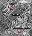
| huidige versie | 18 apr 2007 01:21 |  | 945 × 1.064 (456 kB) | Dnowacki | {{Information |Description=Map of Virginia tech with Norris and West Ambler Johnston Hall highlighted. Basemap from TerraServer (USGS). |Source=self-made |Date=2007-04-17 |Author= en:User:Dnowacki |other_versions= }} |
| 18 apr 2007 01:14 |  | 945 × 1.064 (457 kB) | Dnowacki | == Summary == {{Information |Description=Map of Virginia tech with Norris and West Ambler Johnston Hall highlighted. Basemap from TerraServer (USGS). |Source=self-made |Date=2007-04-17 |Author= en:User:Dnowacki |other_versions= }} == Licensing == {{ |
Bestandsgebruik
Dit bestand wordt op de volgende 2 pagina's gebruikt:
Globaal bestandsgebruik
De volgende andere wiki's gebruiken dit bestand:
- Gebruikt op ar.wiki.x.io
- Gebruikt op ca.wiki.x.io
- Gebruikt op cy.wiki.x.io
- Gebruikt op de.wiki.x.io
- Gebruikt op en.wiki.x.io
- Gebruikt op en.wikinews.org
- Gebruikt op es.wiki.x.io
- Gebruikt op eu.wiki.x.io
- Gebruikt op fi.wiki.x.io
- Gebruikt op fr.wiki.x.io
- Gebruikt op fr.wikinews.org
- Gebruikt op glk.wiki.x.io
- Gebruikt op he.wiki.x.io
- Gebruikt op id.wiki.x.io
- Gebruikt op it.wiki.x.io
- Gebruikt op ja.wikinews.org
- Gebruikt op pt.wiki.x.io
- Gebruikt op pt.wikinews.org
- Gebruikt op ro.wiki.x.io
- Gebruikt op ru.wiki.x.io
- Gebruikt op tt.wiki.x.io
- Gebruikt op vi.wiki.x.io
- Gebruikt op vo.wiki.x.io
- Gebruikt op www.wikidata.org
- Gebruikt op zh-min-nan.wiki.x.io
