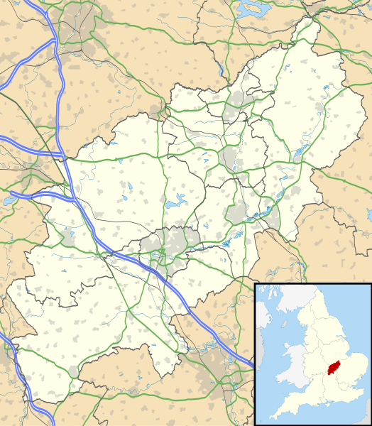
Bestand:Northamptonshire UK location map (1974-2021).svg

Afmetingen van deze voorvertoning van het type PNG van dit SVG-bestand: 524 × 600 pixels Andere resoluties: 210 × 240 pixels | 419 × 480 pixels | 671 × 768 pixels | 895 × 1.024 pixels | 1.789 × 2.048 pixels | 1.106 × 1.266 pixels.
Oorspronkelijk bestand (SVG-bestand, nominaal 1.106 × 1.266 pixels, bestandsgrootte: 2 MB)
Bestandsgeschiedenis
Klik op een datum/tijd om het bestand te zien zoals het destijds was.
| Datum/tijd | Miniatuur | Afmetingen | Gebruiker | Opmerking | |
|---|---|---|---|---|---|
| huidige versie | 21 jun 2022 21:59 |  | 1.106 × 1.266 (2 MB) | G-13114 | Reverted to version as of 19:07, 26 September 2010 (UTC) |
| 21 jun 2022 21:58 |  | 1.383 × 1.583 (59 kB) | G-13114 | Update to reflect local government boundary changes in 2021 | |
| 26 sep 2010 20:07 |  | 1.106 × 1.266 (2 MB) | Nilfanion | {{Information |Description=Map of Northamptonshire, UK with the following information shown: *Administrative borders *Coastline, lakes and rivers *Roads and railways *Urban areas Equirectangular map projection on WGS 84 datum, with |
Bestandsgebruik
Meer dan 100 pagina's gebruiken dit bestand. De volgende lijst geeft alleen de eerste 100 pagina's weer die dit bestand gebruiken. Er is ook een volledige lijst beschikbaar.
- Abthorpe
- Adstone
- Aldwincle
- Apethorpe
- Arthingworth
- Ashby St Ledgers
- Aston le Walls
- Aynho
- Badby
- Barton Seagrave
- Benefield
- Billing (Northamptonshire)
- Blakesley
- Blatherwycke
- Blisworth
- Boddington (Northamptonshire)
- Boughton (Northamptonshire)
- Bozeat
- Brackley
- Bradden
- Brampton Ash
- Braunston
- Braybrooke
- Brigstock
- Brixworth
- Brockhall
- Bugbrooke
- Bulwick
- Burton Latimer
- Byfield
- Canons Ashby
- Castle Ashby
- Catesby
- Chacombe
- Charwelton
- Chipping Warden
- Church Brampton
- Clay Coton
- Clopton (Northamptonshire)
- Cold Ashby
- Cold Higham
- Collingtree
- Collyweston
- Corby
- Cotterstock
- Cottesbrooke
- Courteenhall
- Cransley
- Creaton
- Crick
- Croughton
- Culworth
- Daventry (Engeland)
- Deanshanger
- Deene
- Deenethorpe
- Denford
- Desborough
- Dodford
- Duston
- Earls Barton
- East Carlton
- East Farndon
- East Haddon
- Easton Maudit
- Easton on the Hill
- Ecton
- Evenley
- Everdon
- Eydon
- Farthinghoe
- Farthingstone
- Fawsley
- Finedon
- Flore
- Fotheringhay
- Gayton (Northamptonshire)
- Geddington
- Glapthorn
- Grafton Regis
- Grafton Underwood
- Grange Park
- Great Addington
- Great Doddington
- Great Harrowden
- Great Oxenden
- Greatworth
- Greens Norton
- Gretton
- Guilsborough
- Hackleton
- Hannington (Northamptonshire)
- Hardingstone
- Hargrave (Northamptonshire)
- Higham Ferrers
- Long Buckby
- Norton (Northamptonshire)
- Pattishall
- Rushden (Northamptonshire)
- Towcester
Meer koppelingen naar dit bestand bekijken.
Globaal bestandsgebruik
De volgende andere wiki's gebruiken dit bestand:
- Gebruikt op ar.wiki.x.io
- Gebruikt op bg.wiki.x.io
- Gebruikt op ceb.wiki.x.io
- Gebruikt op cy.wiki.x.io
- Gebruikt op es.wiki.x.io
- Northampton
- Northamptonshire
- Silverstone
- Corby
- Plantilla:Mapa de localización de Northamptonshire
- Rockingham (Northamptonshire)
- Cottingham (Northamptonshire)
- Middleton (Northamptonshire)
- Weldon (Northamptonshire)
- Gretton (Northamptonshire)
- Stanion
- East Carlton
- Wilbarston
- Weston by Welland
- Weekley
- Warkton
- Thorpe Malsor
- Stoke Albany
- Harrington (Northamptonshire)
- Harringworth
- Earls Barton
- East Farndon
- East Haddon
- Easton on the Hill
- Ecton
- Evenley
- Everdon
- Eydon
- Quinton (Northamptonshire)
- Guilsborough
- Aynho
- Aston le Walls
- Yardley Gobion
- Irchester
- Isham
- Scaldwell
- Shutlanger
- Sibbertoft
- Islip (Northamptonshire)
- Yardley Hastings
- Yarwell
- Yelvertoft
- Wilby (Northamptonshire)
- Badby
- Barby (Northamptonshire)
- Barnwell (Northamptonshire)
Globaal gebruik van dit bestand bekijken.