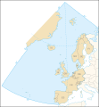
Bestand:OSPAR Commission area map.svg

Afmetingen van deze voorvertoning van het type PNG van dit SVG-bestand: 555 × 600 pixels Andere resoluties: 222 × 240 pixels | 444 × 480 pixels | 710 × 768 pixels | 947 × 1.024 pixels | 1.894 × 2.048 pixels | 740 × 800 pixels.
Oorspronkelijk bestand (SVG-bestand, nominaal 740 × 800 pixels, bestandsgrootte: 202 kB)
Bestandsgeschiedenis
Klik op een datum/tijd om het bestand te zien zoals het destijds was.
| Datum/tijd | Miniatuur | Afmetingen | Gebruiker | Opmerking | |
|---|---|---|---|---|---|
| huidige versie | 9 nov 2006 22:44 |  | 740 × 800 (202 kB) | Sting | White background |
| 9 nov 2006 22:31 |  | 740 × 800 (202 kB) | Sting | {{Information| |Description=Map of the marine area and the 15 contracting parties of the OSPAR Commission for the protection of the marine environment of the North-East Atlantic |Source=Own work, based upon [http://www.ospar.org/eng/html/welcome.html the |
Bestandsgebruik
Dit bestand wordt op de volgende pagina gebruikt:
Globaal bestandsgebruik
De volgende andere wiki's gebruiken dit bestand:
- Gebruikt op ast.wiki.x.io
- Gebruikt op ca.wiki.x.io
- Gebruikt op cs.wiki.x.io
- Gebruikt op da.wiki.x.io
- Gebruikt op de.wiki.x.io
- Gebruikt op de.wiktionary.org
- Gebruikt op en.wiki.x.io
- Gebruikt op es.wiki.x.io
- Gebruikt op fr.wiki.x.io
- Gebruikt op gl.wiki.x.io
- Gebruikt op no.wiki.x.io
- Gebruikt op pt.wiki.x.io
- Gebruikt op sk.wiki.x.io
- Gebruikt op sv.wiki.x.io