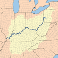
Bestand:Ohiorivermap.png
Ohiorivermap.png (467 × 469 pixels, bestandsgrootte: 76 kB, MIME-type: image/png)
Bestandsgeschiedenis
Klik op een datum/tijd om het bestand te zien zoals het destijds was.
| Datum/tijd | Miniatuur | Afmetingen | Gebruiker | Opmerking | |
|---|---|---|---|---|---|
| huidige versie | 31 jan 2013 23:51 |  | 467 × 469 (76 kB) | Tholme | cropped border |
| 2 mei 2007 20:11 |  | 500 × 500 (267 kB) | Kmusser | increased resolution | |
| 21 jun 2006 16:14 |  | 250 × 250 (98 kB) | Kmusser | This is a map of the Ohio River Watershed. I, Karl Musser, created it based on USGS data. {{self|cc-by-sa-2.5}} Category:Maps of rivers |
Bestandsgebruik
Dit bestand wordt op de volgende pagina gebruikt:
Globaal bestandsgebruik
De volgende andere wiki's gebruiken dit bestand:
- Gebruikt op af.wiki.x.io
- Gebruikt op ar.wiki.x.io
- Gebruikt op azb.wiki.x.io
- Gebruikt op ba.wiki.x.io
- Gebruikt op bcl.wiki.x.io
- Gebruikt op bg.wiki.x.io
- Gebruikt op bh.wiki.x.io
- Gebruikt op bn.wiki.x.io
- Gebruikt op br.wiki.x.io
- Gebruikt op ca.wiki.x.io
- Gebruikt op cs.wiki.x.io
- Gebruikt op da.wiki.x.io
- Gebruikt op da.wikibooks.org
- Gebruikt op de.wiki.x.io
- Gebruikt op el.wiki.x.io
- Gebruikt op en.wiki.x.io
- Gebruikt op en.wiktionary.org
- Gebruikt op es.wiki.x.io
- Gebruikt op et.wiki.x.io
- Gebruikt op fa.wiki.x.io
- Gebruikt op fi.wiki.x.io
- Gebruikt op fr.wiki.x.io
- Gebruikt op fy.wiki.x.io
- Gebruikt op ha.wiki.x.io
- Gebruikt op he.wiki.x.io
- Gebruikt op hr.wiki.x.io
- Gebruikt op hu.wiki.x.io
- Gebruikt op hy.wiki.x.io
- Gebruikt op incubator.wikimedia.org
- Gebruikt op io.wiki.x.io
- Gebruikt op it.wiki.x.io
Globaal gebruik van dit bestand bekijken.
