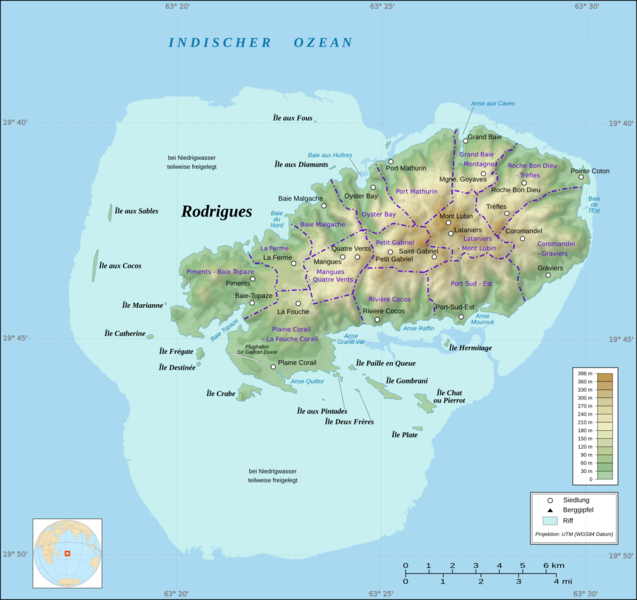
Bestand:Rodrigues Zonenkarte de.png

Grootte van deze voorvertoning: 637 × 600 pixels. Andere resoluties: 255 × 240 pixels | 510 × 480 pixels | 816 × 768 pixels | 1.088 × 1.024 pixels | 1.284 × 1.209 pixels.
Oorspronkelijk bestand (1.284 × 1.209 pixels, bestandsgrootte: 559 kB, MIME-type: image/png)
Bestandsgeschiedenis
Klik op een datum/tijd om het bestand te zien zoals het destijds was.
| Datum/tijd | Miniatuur | Afmetingen | Gebruiker | Opmerking | |
|---|---|---|---|---|---|
| huidige versie | 18 jan 2017 19:40 |  | 1.284 × 1.209 (559 kB) | Vuxi | - asd at bottom of map |
| 18 jan 2017 19:39 |  | 1.284 × 1.209 (559 kB) | Vuxi | - asd at bottom of map | |
| 2 mrt 2010 15:15 |  | 1.284 × 1.209 (549 kB) | Vuxi | + Schriftzug | |
| 1 mrt 2010 22:56 |  | 1.284 × 1.209 (545 kB) | Vuxi | einige Orte | |
| 27 feb 2010 22:36 |  | 1.284 × 1.209 (539 kB) | Vuxi | + Namen der Zonen + Orte - Berge | |
| 26 feb 2010 11:45 |  | 1.284 × 1.209 (524 kB) | Vuxi | {{Information |Description={{de|1=Zonenkarte der Insel Rodrigues}} |Source={{own}} |Author=Vuxi |Date= |Permission= |other_versions= }} topographic map:File:Rodrigues Island topographic map-de.svg, borders: [http://www.gov.mu/portal/sit |
Bestandsgebruik
Dit bestand wordt op de volgende 2 pagina's gebruikt:
Globaal bestandsgebruik
De volgende andere wiki's gebruiken dit bestand:
- Gebruikt op bn.wiki.x.io
- Gebruikt op ceb.wiki.x.io
- Gebruikt op de.wiki.x.io
- Gebruikt op en.wiki.x.io
- Gebruikt op eo.wiki.x.io
- Gebruikt op fr.wiki.x.io
- Gebruikt op hu.wiki.x.io
- Gebruikt op it.wiki.x.io
- Gebruikt op ja.wiki.x.io
- Gebruikt op nl.wiktionary.org
- Gebruikt op pl.wiki.x.io
- Gebruikt op ro.wiki.x.io
- Gebruikt op tr.wiki.x.io
- Gebruikt op uk.wiki.x.io
- Gebruikt op vi.wiki.x.io
- Gebruikt op www.wikidata.org
- Gebruikt op yo.wiki.x.io
- Gebruikt op zh.wiki.x.io