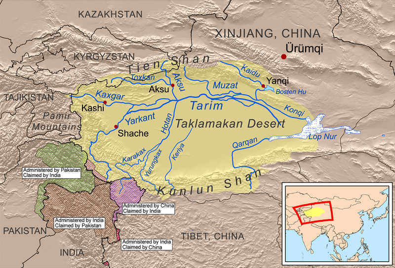
Bestand:Tarimrivermap.png

Grootte van deze voorvertoning: 800 × 543 pixels. Andere resoluties: 320 × 217 pixels | 640 × 434 pixels | 1.024 × 695 pixels | 1.449 × 983 pixels.
Oorspronkelijk bestand (1.449 × 983 pixels, bestandsgrootte: 2,09 MB, MIME-type: image/png)
Bestandsgeschiedenis
Klik op een datum/tijd om het bestand te zien zoals het destijds was.
| Datum/tijd | Miniatuur | Afmetingen | Gebruiker | Opmerking | |
|---|---|---|---|---|---|
| huidige versie | 13 apr 2020 19:08 |  | 1.449 × 983 (2,09 MB) | Kmusser | adjustments to China-India border claims |
| 11 mrt 2020 14:17 |  | 1.449 × 983 (2,09 MB) | Kmusser | crop out border | |
| 11 mrt 2020 14:14 |  | 1.467 × 1.000 (2,1 MB) | Kmusser | update China-Tajikistan border | |
| 3 feb 2010 15:36 |  | 1.467 × 1.000 (2,18 MB) | Kmusser | fix typo | |
| 15 dec 2008 21:56 |  | 1.467 × 1.000 (2,18 MB) | Kmusser | {{Information |Description=This is a map of the Tarim River drainage basin. |Source=Own work using http://www.maproom.psu.edu/dcw/ Digital Chart of the World and [[http://edc.usgs.gov/products/elevation/gtopo30/ |
Bestandsgebruik
Dit bestand wordt op de volgende 5 pagina's gebruikt:
Globaal bestandsgebruik
De volgende andere wiki's gebruiken dit bestand:
- Gebruikt op af.wiki.x.io
- Gebruikt op ar.wiki.x.io
- Gebruikt op arz.wiki.x.io
- Gebruikt op as.wiki.x.io
- Gebruikt op azb.wiki.x.io
- Gebruikt op az.wiki.x.io
- Gebruikt op ba.wiki.x.io
- Gebruikt op be.wiki.x.io
- Gebruikt op bg.wiki.x.io
- Gebruikt op bn.wiki.x.io
- Gebruikt op br.wiki.x.io
- Gebruikt op ca.wiki.x.io
- Gebruikt op ceb.wiki.x.io
- Gebruikt op cs.wiki.x.io
- Gebruikt op da.wiki.x.io
- Gebruikt op de.wiki.x.io
- Gebruikt op en.wiki.x.io
Globaal gebruik van dit bestand bekijken.