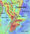
Bestand:Zealandia, topographic map.jpg

Grootte van deze voorvertoning: 529 × 600 pixels. Andere resoluties: 212 × 240 pixels | 423 × 480 pixels | 678 × 768 pixels | 903 × 1.024 pixels | 1.500 × 1.700 pixels.
Oorspronkelijk bestand (1.500 × 1.700 pixels, bestandsgrootte: 4,57 MB, MIME-type: image/jpeg)
Bestandsgeschiedenis
Klik op een datum/tijd om het bestand te zien zoals het destijds was.
| Datum/tijd | Miniatuur | Afmetingen | Gebruiker | Opmerking | |
|---|---|---|---|---|---|
| huidige versie | 9 feb 2019 17:55 |  | 1.500 × 1.700 (4,57 MB) | Ulanwp | spelling of Bollons Seamount corrected |
| 21 mrt 2017 21:43 |  | 1.500 × 1.700 (4,57 MB) | Ulanwp | Geographical Names inserted | |
| 20 mrt 2017 20:59 |  | 1.500 × 1.700 (4,44 MB) | Ulanwp | {{Information |Description ={{en|1=Topographic map of Zealandia, based on bathmetry data from Scripps Institution of Oceanography, University of California, San Diego}} |Source =http://topex.ucsd.edu/WWW_html/mar_topo.html |Author =U... |
Bestandsgebruik
Dit bestand wordt op de volgende 2 pagina's gebruikt:
Globaal bestandsgebruik
De volgende andere wiki's gebruiken dit bestand:
- Gebruikt op ar.wiki.x.io
- Gebruikt op ast.wiki.x.io
- Gebruikt op bg.wiki.x.io
- Gebruikt op ca.wiki.x.io
- Gebruikt op ceb.wiki.x.io
- Gebruikt op de.wiki.x.io
- Lord Howe Rise
- Zealandia
- Gisborne-Erdbeben von 2007
- Geologie Neuseelands
- Geographie Neuseelands
- Chatham Rise
- Campbell Plateau
- Bounty Trough
- Norfolk Ridge
- New Caledonia Trough
- Challenger Plateau
- Geologie der Antarktischen Halbinsel
- Geologie Ostantarktikas
- Vulkanische Provinzen der Antarktischen Halbinsel
- Gebruikt op en.wiki.x.io
- Chatham Rise
- Lord Howe Rise
- South Tasman Rise
- Campbell Plateau
- Meiolania
- Challenger Plateau
- Lord Howe Seamount Chain
- Zealandia
- Continent
- Submerged continent
- East Tasman Plateau
- Bollons Seamount
- Bounty Trough
- Tasmantid Seamount Chain
- Tasmantid hotspot
- Joseph Gilbert Seamount
- Gascoyne Seamount
- Geology of New Caledonia
- Taupo Bank
- Derwent Hunter Guyot
- Britannia Guyots
- Queensland Guyot
- Geology of Zealandia
- Three Kings Ridge
- Gebruikt op es.wiki.x.io
- Gebruikt op eu.wiki.x.io
- Gebruikt op fr.wiki.x.io
Globaal gebruik van dit bestand bekijken.